


![]()
TRAIL MAP - RigAntoCa - Genova (GE)
![]() La storica lunga marcia, organizzata dal
CAI Sez. Sampierdarena,
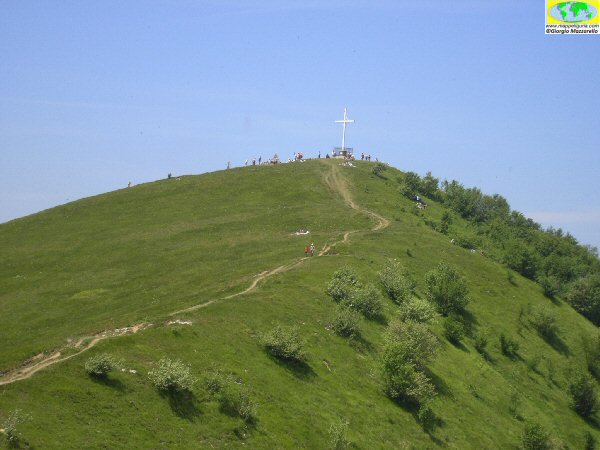
che dal Parco Urbano delle Mura, situato sulle alture di Genova, raggiunge il Monte Antola,
cuore e perno dell'omonimo Parco Naturale.
La storica lunga marcia, organizzata dal
CAI Sez. Sampierdarena,
che dal Parco Urbano delle Mura, situato sulle alture di Genova, raggiunge il Monte Antola,
cuore e perno dell'omonimo Parco Naturale.
Quasi 42 km di cammino con 2150m di dislivello in salita e 1250m in discesa, per immergersi nella natura dei fitti boschi e dei panoramici crinali
dell'Appennino Genovese.
Un lungo percorso su antiche vie di commercio e di pellegrinaggio toccando chiesette campestri cappellette ed edicole votive
che testimoniano la passata forte spiritualita' popolare, sentita ancora oggi dalle genti delle vallate.
![]() The historic long march, organized by the
CAI Sampierdarena Section,
which starts from the Parco Urbano delle Mura, located in the mountains behind Genova, and reach Antola Mountain,
heart of the Antola Natural Park .
The historic long march, organized by the
CAI Sampierdarena Section,
which starts from the Parco Urbano delle Mura, located in the mountains behind Genova, and reach Antola Mountain,
heart of the Antola Natural Park .
Almost 42 km of the route with 2150m of ascent and 1250m descent, to plunge into the nature of the thick woods and scenic ridges of the Apennines Genovese.
A long path of ancient trade routes and pilgrimage, touching the small rural churches, chapels and shrines,
which bear witness to the past strong popular spirituality, still felt by the people of the valleys.
ATTENZIONE / WARNING
QUESTO NON E' IL SITO UFFICIALE DELLA RIGANTOCA
ma sono solo alcune pagine che ho voluto dedicare alla storica marcia.
Per maggiori informazioni e dati ufficiali consulta:
SITO UFFICIALE DELLA MANIFESTAZIONE
![]() ed al sito del
ed al sito del
CAI SEZ. DI SAMPIERDARENA
![]()
WARNING
THIS IS NOT THE OFFICIAL SITE OF THE RIGANTOCA
but it is only a web-page which I have devoted to historic march.
For more information and official data on the event see
OFFICIAL WEBSITE OF THE EVENT
![]() and se
and se
CAI SECTION OF SAMPIERDARENA
![]()
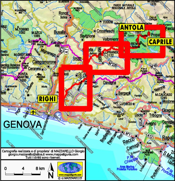
RigAntoCa - Righi-Antola-Caprile
Marcia non competitiva / Non competitive march
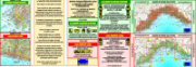
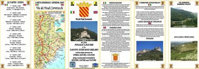
- Carte di Dettaglio+Profilo Altimetrico+Descrizione del percorso (consultabili liberamente - vedi sotto)
- Traccia GPS (disponibile su richiesta)
- Qualche foto del percorso
- Detailed maps+Height Profile+Route Description (freely visible - see below)
- GPS Track (available on demand)
- Some pictures of the route
- TrailMAP - RigAntoCa - Tavola 1
(tratto RIGHI - CAPPELLETTA DI SELLA) - TrailMAP - RigAntoCa - Tavola 2
(tratto CAPPELLETTA DI SELLA - MADONNA DELLA GUARDIA DI PENTEMA) - TrailMAP - RigAntoCa - Tavola 3
(tratto MADONNA DELLA GUARDIA DI PENTEMA - CAPRILE) - TrailMAP - RigAntoCa - Sheet 1
(section RIGHI - CAPPELLETTA DI SELLA) - TrailMAP - RigAntoCa - Sheet 2
(section CAPPELLETTA DI SELLA - MADONNA DELLA GUARDIA DI PENTEMA) - TrailMAP - RigAntoCa - Sheet 3
(section MADONNA DELLA GUARDIA DI PENTEMA - CAPRILE)
41,5 km - +2150 m -1250 m
(76% di sentieri - 16% di sterrate - 8% di asfaltate)
(76% foot-paths - 16% dirt roads - 8% paved roads)
SVILUPPO SINTETICO DEL PERCORSO / ROUTE SUMMARY
MATERIALE DISPONIBILE:
In occasione di questo classico evento, per tutti coloro che desiderano conoscere il percorso ho preparato:
AVAILABLE DOCUMENTS:
On the occasion of this classic event for all those who want to know the route, I have prepared the following documents:
CARTE DI DETTAGLIO DEL PERCORSO
seleziona la tavola da consultare dalla lista o dalla carta sottostante
DETAILED MAPS OF ROUTE
select the sheet to see from the list or from the map below
Sei interessato a queste carte? Richiedi ulteriori informazioni
Are you interested in these maps? Write me
NOTE:
Il percorso, che transita su sterrate e sentieri sempre ben evidenti e segnalati, pur non presentando particolari difficolta' tecniche,
a causa della notevole lunghezza e dislivello, e' consigliato solo a persone abituate a camminare per molte ore consecutivamente.
Per chi volesse invece effettuare anche solo parte del percorso, al di fuori della manifestazione,
e' possibile realizzare facili e relativamente brevi anelli alla portata di tutti,
tramite i tanti sentieri che, partendo dai paesi o dalle frazioni vicine, intersecano il percorso principale.
Tutti questi sentieri sono indicati sia sulle varie Tavole delle carte
Trail MAP della RigAntoCa, sia sulle varie Tavole delle
Carte Escursionistiche della collana mMOA che sono:
Tavola GE-18 (tratto Partenza - versante est Forte Puin)
Tavola GE-19 (tratto versante est Forte Puin - Cappelletta di Sella)
Tavola GE-27 (tratto Cappelletta di Sella - Monte Liprando)
Tavola GE-34 (tratto Monte Liprando - Cappelletta del Colletto)
Tavola GE-35 (tratto Cappelletta del Colletto - Monte Antola)
Tavola GE-38 (tratto Monte Antola - Caprile)
Tutti i dati e le informazioni qui riportare e relative al percorso,
pur derivando da recenti verifiche sui sentieri della RigAntoCa fatte personalmente, potrebbero subire
variazioni come locali e limitate modifiche del tracciato (causate da possibili eventi naturali
non prevedibili come piccoli smottamenti) o modifiche delle
postazioni o degli orari dei cancelli (causati da esigenze organizzative).
Si raccomanda pertanto, il giorno della manifestazione, prima di intraprendere la marcia, sia di accertarsi
che non ci siano modifiche tramite la consultazione SITO UFFICIALE DELLA MANIFESTAZIONE
sia di informarsi al momento della partenza.
Tutto il tracciato della RigAntoCa e' stato percorso dall'autore con un
GPS Garmin Oregon
da cui derivano i dati riportati relativi a distanza, quota e dislivello.
Questi dati, essendo comunque affetti da errori ed imprecisioni dovute a molteplici fattori,
possono differire da quanto riportato sul sito ufficiale della manifestazione.
ATTENZIONE:
per il 2015 la parte iniziale del tracciato ha subito la seguente piccola modifica:
Non si passa piu' dall'Osteria delle Baracche ma si prosegue sempre sulla strada sterrata Righi-Valico di Trensasco
nota anche come strada sterrata dell'Acquedotto Val Noci.
Questa modifica non e' ancora riportata sulle mie carte.
NOTES:
Entire route, which passes on dirt and footpaths which are always clearly visible and marked,
not particularly difficult, but because of its great length and height difference,
it is recommended only for people used to walk for many hours consecutively.
For those who wish to perform only part of the route outside the date of the event,
you can make an easy and relatively short rings affordable for everyone, by concatenating
the many paths which, starting from the neighboring villages, intersect the main route.
All these paths are shown both on the various sheets of the maps
Trail MAP of RigAntoCa, both on the various Sheets of
Hiking Maps type mMOA which are following:
Sheet GE-18 (section Partenza - versante est Forte Puin)
Sheet GE-19 (section versante est Forte Puin - Cappelletta di Sella)
Sheet GE-27 (section Cappelletta di Sella - Monte Liprando)
Sheet GE-34 (section Monte Liprando - Cappelletta del Colletto)
Sheet GE-35 (section Cappelletta del Colletto - Monte Antola)
Sheet GE-38 (section Monte Antola - Caprile)
All data and information relating to the location and return here,
although resulting from recent tests on the paths of RigAntoCa, made personally,
may be subject to variations such as local and limited changes of the track
(due to possible natural events not foreseeable as small landslides)
or changes in the supply points or schedules of the gates (caused by organizational needs).
I therefore recommend, on the day of the event, before embarking on the march,
to see the OFFICIAL SITE OF THE RIGANTOCA
and to ask to the staff before the start.
The entire route of the race was walking path by the author using a
GPS Garmin Oregon
in order to record all the data reported in these pages (distance and altitude)
These data, however, being affected by errors and inaccuracies due to multiple
factors, may differ from those reported on the official website of the event.
WARNING:
for 2015 the initial part of the route underwent the following small change:
Not more passes from Osteria Barracks but you continue on the dirt road Righi-Valico di Trensasco, also known as dirt road dell'Acquedotto Val Noci.
This change has not yet reported on my maps.
![]()
SITO UFFICIALE DELLA MANIFESTAZIONE
![]()
SITO DEL CAI SEZ. SAMPIERDARENA - ORGANIZZATORE UFFICIALE DELLA RIGANTOCA
