


![]()
mini MAPPE OUTDOOR ACTIVITIES e GPS
Introduzione
Di ogni tavola delle mie carte escursionistiche collana mMOA (mini MAPPE OUTDOOR ACTIVITIES), ho anche realizzato i files .kmz
da poter memorizzare all'interno dei ricevitori GPS portatili che accettano e gestiscono
mappe di tipo "raster", cioe' mappe costituite da immagini bitmap.
In commercio esistono diversi ricevitori GPS che sono in grado di fare cio'.
A titolo di esempio cito quelli della Garmin che sono le serie:
- Oregon
- Colorado
- eTrex
- Dakota
- GPSMAP
- Montana
- Edge
- Monterra
Per l'elenco esatto vedi: Pagina del sito Garmin
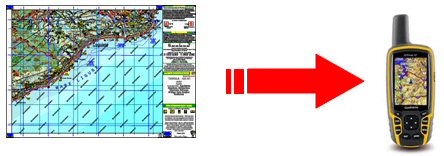
In linea generale per poter memorizzare le mMOA sul GPS e' necessario creare un file contenente
l'immagine bitmap della mappa georeferenziata.
L'operazione di georeferenziazione consiste in pratica nel posizionare l'immagine della carta
sul globo terrestre esattamente sulla porzione di territorio che rappresenta, in modo
che i vari oggetti rappresentati sulla carta, siano esattamente sulle coordinate degli oggetti
reali sulla terra.
Questa procedura, apparentemente complessa, e' piu' semplice di quanto sembra e puo'
essere fatta utilizzando programmi specifici come OkMap, GoogleEarth ecc..
E' proprio questa fase una vera e propria "prova del nove" della bonta' della carta in termini di precisione e rispetto di tutti i parametri del disegno topografico.
In parole semplici, le carte che rispettano tutte le regole delle proiezioni e degli standard topografici, quando georeferenziate,
risulteranno sposare perfettamente le foto satellitari (ortorettificate) del territorio, mentre quelle con un disegno piu' approssimativo
avranno scostamenti anche significativi.
La preparazione delle mappe raster georeferenziate deve essere fatta anche rispettando le specifiche
dello strumento sul quale si vogliono caricare, che nel caso dei GPS Garmin sono:
Ogni immagine mappa non deve essere piu' grande di 1024x1024 pixel;
Non si possono caricare sul ricevitore piu' di 100 mappe contemporaneamente ove per mappa si intende una tavoletta da 1024x1024 pixel
Le "Custom Maps" si possono utilizzare assieme alle eventuali mappe vettoriali presenti sul GPS
che risulterebbero un ulteriore bagaglio di informazioni del territorio visualizzate dallo strumento.
Le eventuali tracce di strade, sentieri ecc. presenti sulle mappe vettoriali comparirebbero sopra alla mappa
raster.
Alla seguente pagina mMOA-EsempiDownload la possibilita' di scaricare una Tavola di esempio nei vari formati.
Sei interessato alle carte escursionistiche della mia collana mMOA da caricare sul GPS? CONTATTAMI
Overview
For each mMOA (mini MAPPE OUTDOOR ACTIVITIES)
I have also prepared a .kmz file which can be stored within the portable GPS receivers
equipped to handle maps of type "raster", ie maps consist of bitmap images.
In the market there are different GPS receivers that are capable of handling raster maps,
for example, Garmin has the following types:
- Oregon
- Colorado
- eTrex
- Dakota
- GPSMAP
- Montana
- Edge
- Monterra
Complete and updated list: Garmin web page
In general, in order to store the mMOA maps on your GPS you need to create a file containing the bitmap image of georeferenced map.
The process of georeferencing is to place the image of the map on the globe exactly on the portion of land that represents,
so that the various objects drawn on the map, are exactly on the coordinates of real objects on the ground.
This procedure, seemingly complex, it is easier than it sounds and can be done by using specific software
such as OkMap, GoogleEarth etc..
This stage is a real "litmus test" of the goodness of the map in terms of accuracy and compliance with all the parameters of the topographical drawing.
In simple words, the maps that comply with all the rules of the projections and standard topographic be perfectly overlapping
satellite photos (orthorectified) of the territory, while those with a more rough drawing will be significant
differences between photos and map.
The preparation of raster maps georeferenced must also be made respecting
the parameters of the GPS which, in the case of GPS Garmin are the following:
Each map image must not be larger than 1024x1024 pixels;
You can not store more than 100 maps at the same time. Map is a tile of 1024x1024 pixels
The "Custom Maps" can be used together with any vector maps on the GPS that would be
an additional background information of the area viewed by the instrument.
Tracks of all element of vector maps (roads, paths etc.) appear above the raster map.
On following webpage mMOA-EsempiDownload you can download an example of Sheet-Map.
Are you interested about hiking maps of my mMOA type maps, to store on your GPS receiver? WRITE ME
mMOA georeferenziate e su GPS
Tralascio le procedure e le metodologie su come preparare le mappe raster da poter
caricare su GPS in quanto nella rete sono presenti molti siti con estese e dettagliate spiegazioni
sulla preparazione delle "Custom Maps"(nome dato da Garmin alle mappe raster da caricare sul GPS) come per esempio i seguenti:
- Spiegazioni dal sito ufficiale Garmin
- Documento tutorial dal sito ufficiale Garmin
- Spiegazioni dal sito mbaro.altervista.org
- Tutorial dal sito www.scintilena.com
- Video su YuTube
Per rendere l'idea di una mMOA raster georeferenziata
riporto di seguito alcune immagini rappresentative della potenzialita' di utilizzo delle
mMOA assieme ad un ricevitore GPS.
Georeferenced mMOA and stored on GPS
I omit the procedures and methodologies on the preparation of raster maps to be stored on the GPS because on the internet
there are many web-sites with extensive and detailed explanations, such as the following:
- Explanations on the official web-site Garmin
- Tutorial on the official site Garmin
- Explanations from the web-site mbaro.altervista.org
- Tutorial on web-site www.scintilena.com
- Video on YuTube
In order to make the idea of a mMOA georeferenced,
I reproduce below some images representative of the potential
use of the mMOA together with a GPS receiver.
mMOA Georeferenziate / Georeferenced mMOA
![]()
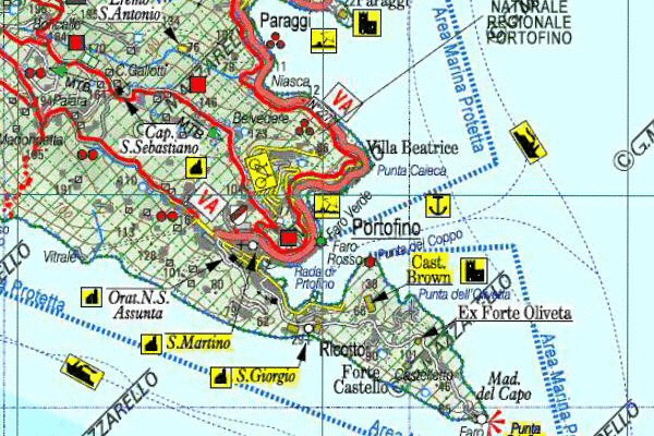
Qui sotto un paio di immagini in dissolvenza tra carta e immagine satellitare di Google-Earth
di alcune porzioni di mMOA.
Below a couple of images fading between map and satellite view of Google-Earth
portions of mMOA.
La zona di Portofino (PARCO DI PORTOFINO) della mMOA-Tavola GE-43.
Portofino area (PARCO DI PORTOFINO) of mMOA-Tavola GE-43.
La zona del Monte Antola (PARCO DELL'ANTOLA) della mMOA-Tavola GE-35.
Monte Antola (PARCO DELL'ANTOLA) of mMOA-Tavola GE-35.
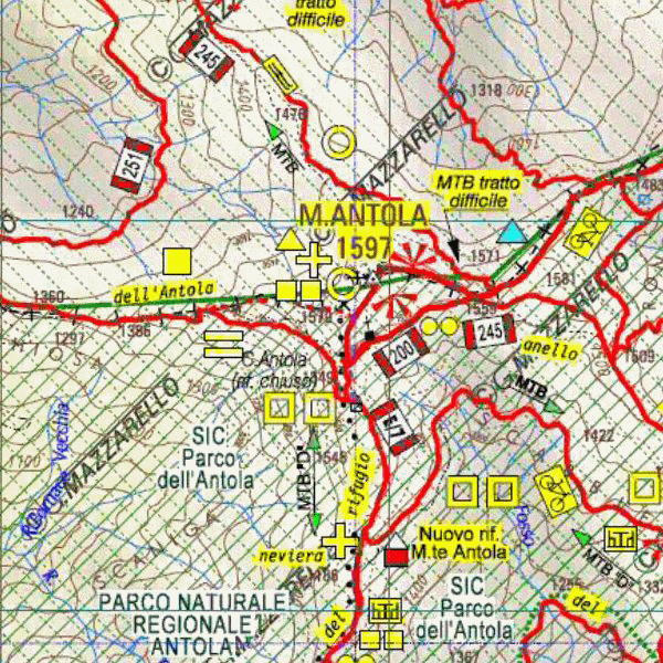
![]() Come si puo' notare la sovrapposizione tra la carta e la foto e' quasi perfetta. Questo significa che quando si utilizzeranno le
mMOA georeferenziate all'interno di una unita' GPS, la corrispondenza tra la
propria posizione e la carta visualizzata sotto, sara' ottima.
Come si puo' notare la sovrapposizione tra la carta e la foto e' quasi perfetta. Questo significa che quando si utilizzeranno le
mMOA georeferenziate all'interno di una unita' GPS, la corrispondenza tra la
propria posizione e la carta visualizzata sotto, sara' ottima.
![]() As you can see the overlap between the map and the photo is almost perfect.
This means that when you use the georeferenced within a GPS,
the correspondence between its position and the paper appears below, it will be great.
As you can see the overlap between the map and the photo is almost perfect.
This means that when you use the georeferenced within a GPS,
the correspondence between its position and the paper appears below, it will be great.
mMOA sul GPS / mMOA stored on GPS
![]()
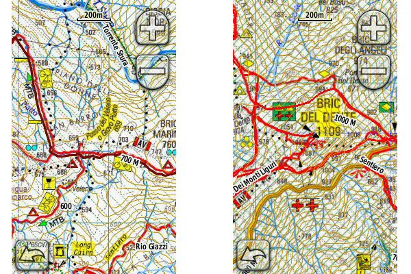
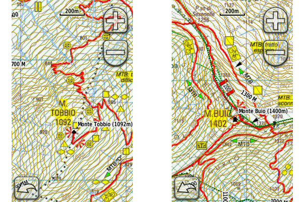
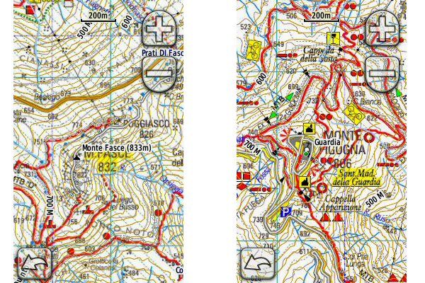
Riporto qui sotto alcune schermate del GPS Garmin Oregon con caricate le mMOA
Below some screen images of my GPS Garmin Oregon with stored the mMOA maps
A SX la zona del Passo del Veleno (GE) (PARCO DEL BEIGUA)appartenente alla mMOA-Tavola GE-10
A DX la zona del Bric del Dente (GE) (PARCO DEL BEIGUA)appartenente alla mMOA-Tavola GE-07
On left Passo del Veleno (GE) (PARCO DEL BEIGUA) of the mMOA-Tavola GE-10
On right Bric del Dente (GE) (PARCO DEL BEIGUA) of the mMOA-Tavola GE-07
A SX la zona del Monte Tobbio (AL) appartenente alla mMOA-Tavola AL-02
A DX la zona del Monte Buio (GE-AL) appartenente alla mMOA-Tavola GE-35
On left Monte Tobbio (AL) of the mMOA-Tavola AL-02
On right Monte Buio (GE-AL) of the mMOA-Tavola GE-35
A SX la zona del Monte Fasce (GE) appartenente alla mMOA-Tavola GE-29
mentre a DX la zona del Monte Figogna (GE) appartenente alla mMOA-Tavola GE-15
On left Monte Fasce (GE) of the mMOA-Tavola GE-29
On right Monte Figogna (GE) of the mMOA-Tavola GE-15
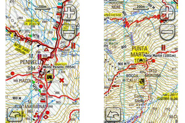
A SX la zona del Monte Pennello (GE) appartenente alla mMOA-Tavola GE-10
A DX la zona di Punta Martin (GE) appartenente alla mMOA-Tavola GE-10
On left Monte Pennello (GE) of the mMOA-Tavola GE-10
On right Punta Martin (GE) of the mMOA-Tavola GE-10
![]() Chi desidera avere maggiori informazioni su questo argomento, mi
puo' contattare.
Chi desidera avere maggiori informazioni su questo argomento, mi
puo' contattare.
![]() If you would like more information about this topic
please write me
If you would like more information about this topic
please write me
