


![]()
mini MAPPE OUTDOOR ACTIVITIES
ESEMPIO SCARICABILE DI UNA TAVOLA
EXAMPLE OF A SHEET-MAP FOR DOWNLOAD
ATTENZIONE:
L'uso di questo materiale DEVE ESSERE PER SCOPI STRETTAMENTE PERSONALI.
No pubblicazione su siti web e sui media senza autorizzazione scritta
WARNING:
The use of these documents MUST BE FOR STRICTLY PERSONAL PURPOSES.
No publication on websites and on the media without written permission
Versione da stampare su carta in formato A3
Clicca sull'immagine sottostante per il downlonad del file .jpg (13 Mb)
Format to print on a A3 paper
Clik on below image for download file .jpg (13 Mb)

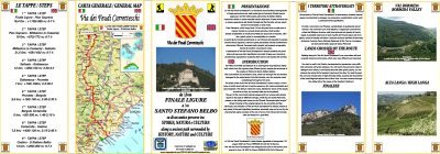
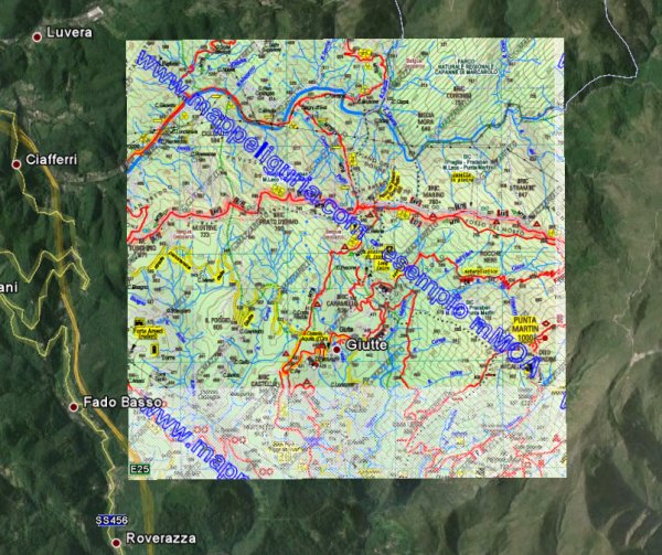
NOTE sulla Tavola in formato .jpg
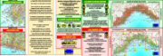
File di esempio di una Tavola in ALTA DEFINIZIONE (Tavola GE-10), delle mie Carte Escursionistiche collana
mMOA, parzialmente ofuscata per ovvi motivi, che illustra il livello di dettaglio di questa tipologia di Carte Topografiche.
Stampando questo files su carta formato A3 al 100% della dimensione, si ha una carta in scala 1:25.000.
NOTICE about Sheet-map .jpg format
Example files concerning a HIGH RESOLUTION Sheet-map (Sheet GE-10), of my Hiking Maps
mMOA type. This file, which is partially hidden for obvious reasons, shows the level of detail of this type of Topographic Maps.
Printing this file on A3 paper size, with 100% of the dimension, you have a map scale 1:25.000.
Versione "Custom Map" da caricare sul GPS
Clicca sull'immagine sottostante per il downlonad del file .kmz (0,6 Mb)
"Custom Map" format to store inside GPS receiver
Clik on below image for download file .kmz (0,6 Mb)
NOTE sulla Tavola formato "Custom Map" (.kmz)
Questa tavola di esempio (Tavola GE-10),
rappresenta la parte in chiaro della tavola soprastante, memorizzata in formato "Custom Map", adatta ad essere memorizzata all'interno dei ricevitori GPS di tipo cartografico.
Livello di definizione del file "Custom Map"
Come e' possibile vedere aprendo questo file con Google-Earth,
il livello di definizione dell'immagine contenuta non e' molto elevato (corrisponderebbe ad una mappa scansionata con 160 dpi) ma, a mio giudizio, e' il compromesso piu' bilanciato per:
- avere ogni tavola memorizzata in 4 files che rispettino i requisiti delle "Custom Maps" (al massimo 1024x1024 pixel per ogni file)
- permettere di memorizzare una porzione di territorio sufficientemente ampia, tenendo presente che, all'interno dei GPS, al massimo si possono memorizzare 100 files "Custom-Maps".
Con questo livello di definizione, all'interno del GPS e' possibile memorizzare al massimo 25
delle mie tavole collana mMOA quindi, considerando che ogni tavola copre un'area di 8x6,5 km (52 kmq),
e' possibile avere la cartografia di 1300 kmq (quadrato di 36 km di lato)
che dal punto di vista escursionistico rappresentano una buona porzione di territorio.
Ovviamente e' possibile incrementare la risoluzione di ogni immagine della mappa.
Per esempio, portando il n. di files da 4 a 9 per ogni tavola (corrispondente ad una mappa scansionata a 240 dpi), all'interno di un GPS al massimo si potrebbero
memorizzare 11 delle mie tavole, che corrisponderebbero ad un territorio di 572 kmq (24 x 24 km).
Comunque il livello di dettaglio e' un parametro che posso modificare a piacimento.
Alla seguente pagina mMOA e GPS e' possibile leggere qualche ulteriore approfondimento su questo argomento.
NOTICE about Sheet-Map format "Custom Map" (.kmz)
This example of Sheet-Map (Sheet GE-10) in "Custom-Map" format ,
is the not hidden area of above map, suitable to be stored within GPS cartographic type receivers.
Image resolution of the file "Custom Map"
As you can see by opening this file with Google-Earth,
the resolution of the image contained in this file is not very high (it corresponds to a map scanned with 160 dpi)but, in my opinion, it is the most balanced compromise in order:
- to have each Sheet-Map stored with 4 files, which meet the requirements of the Custom-Maps (max resolution of 1024x1024 pixel for each file)
- to store inside the GPS receiver, a large enough land area, taking into account that, within the GPS, you can store a maximum of 100 files "Custom-Maps".
With this level of definition, within the GPS, you can store up to 25 Sheet-Maps of my mMOA type Hiking-Map then,
considering that each Sheet-Map covers an area of 8x6,5 km (52 sq km), it is possible to store the mapping of 1300 sq km (square of 36 km of side).
From the hiking point of view, this area represent a good portion of territory.
Of course you can increase the resolution of each image of the map.
For example, increasing the n. of files from 4 to 9 for each Sheet-Map (it corresponds to a map scanned with 240 dpi),
within a GPS it is possible to store up to 11 Sheet-Maps of my mMOA type Hiking-Map, which is a area of 572 square kilometers (24 x 24 km) .
However, the level of detail is a parameter that I can change.
On following webpage mMOA and GPS, you can read some further discussion on this topic.
Sei interessato alle varie Tavole in ALTA DEFINIZIONE?
CONTATTAMI,
Are you interested about various Sheets-Map with HIGH RESOLUTION?
WRITE ME,
